Frontline Visual Intelligence / Raven · RV-001 / 2026.04

From pixels to intelligence.

Raven is Graylark’s frontline visual intelligence platform. It reads pixels, identifies signals, and returns actionable leads in seconds — no metadata required.

Scroll to learn more about Raven

Raven

Raven — Street Targeting narrowing to an exact address in Las Vegas, top match confirmed

No metadata required — a single image is enough.

TIME
7 days
From photo to actionable lead
PRECISION
5,000 km
Street-targeted accuracy
COVERAGE
1 city
Global reach
A new name / Effective 2026.04
Formerly GeoSpy
Now
Raven
Same model. Same team. Same work. A new name — as the first intelligence system from Graylark.
§01The Raven platform

Every pixel carries a clue.

Raven is Graylark's visual intelligence platform. We train AI to understand the world — so it can read every detail in an image and tell you what it means.

What would take hours of manual review returns as high-confidence intelligence in seconds.

Raven · Live geoestimation
Graylark · Raven core
INPUT · LOW-CONTEXT IMAGE
An empty concrete driveway through a lawn lined with live oaks — low-context source image
0.81foliage species
0.74sky gradient
0.69distant signage
0.58curb · concrete
0.52light angle
0.48pavement texture
INFERRED LOCATION
COORDINATE
30.2672° N
-97.7431° W
REGION
Austin, TX
RADIUS
1.2 km
CONFIDENCE94%
NEIGHBORHOODS
  • South Lamar 94%
  • Zilker 87%
  • Bouldin Creek 81%
  • Barton Hills 76%
No metadata · no landmarks · no text
Every pixel carries a clue.
Fragments in. Intelligence out.
§  Capabilities  ·  Today

One platform. Three answers.

Raven reads a single image and returns intelligence an investigator can act on — three distinct ways today, with more always in deployment.

INPUT  ·  ONE FRAME
Single low-context photograph fed into Raven A B C
NO METADATA  ·  NO LANDMARKS  ·  NO TEXT
A
FOLIAGE · BIOME
Texas live oak0.81
Subtropical · 32°–33°N0.74
B
STREET SURFACE
Stamped concrete · residential0.62
Curb paint · US-spec0.58
C
VEHICLE · MAKE / MODEL
2024 Ford F4500.90
White · service body0.86
Where
Geoestimation
South Lamar, Austin  ·  94%
§ 02
Which
Street Targeting
1204 Westmoreland Blvd  ·  ±3 m
§ 03
What
CAR-ID
2024 Ford F450  ·  90% match
§ 04
New capabilities always in deployment
§02Find Region·Geoestimation 02

No landmarks. No metadata. Just a region.

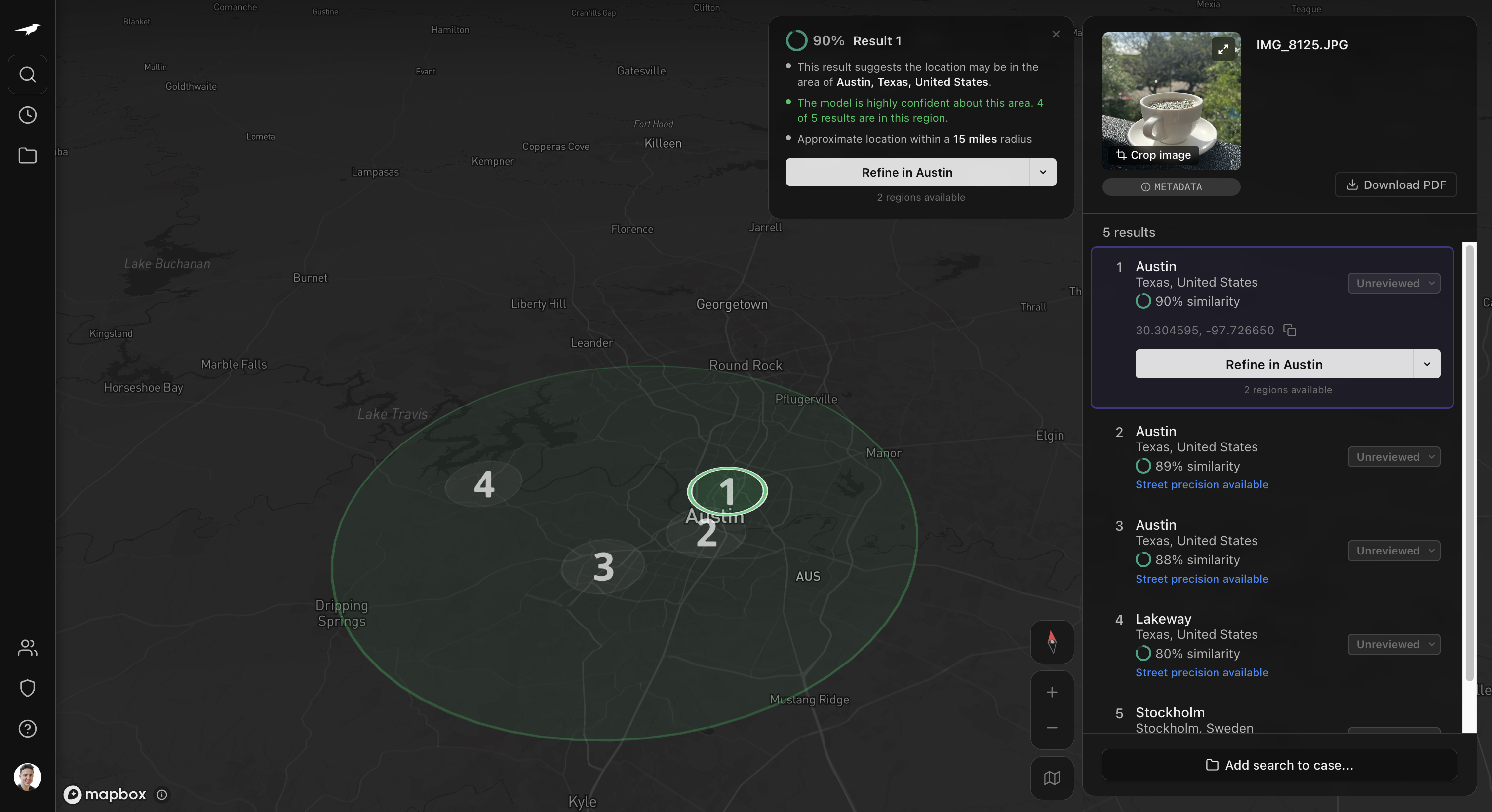
Geoestimation reads environment, structure, and context from a single image — returning ranked, high-confidence regions in seconds.

One frame in. A city out.

Input
No metadata
Low-context phone photograph of a coffee cup on a balcony — out-of-focus trees in background
Single frame · no landmarks · no EXIF required
Raven · Geoestimation
Vision transformer decomposes the frame into vegetation, soil, architecture, sky — inferring a region directly from those signals.
Model view
Direct Inference
$ downsampled · luminance · edges
Returned in seconds
Live result
Raven Find Region result — Austin, Texas, United States · 90% match, 4 of 5 results in region
Identified
Austin, Texas · United States
Coordinates
30.3045°N, −97.7266°W
Radius
~15 mi
90%match · 4 of 5 in region
§03Find Street·Street Targeting 03

Built for low-context images.

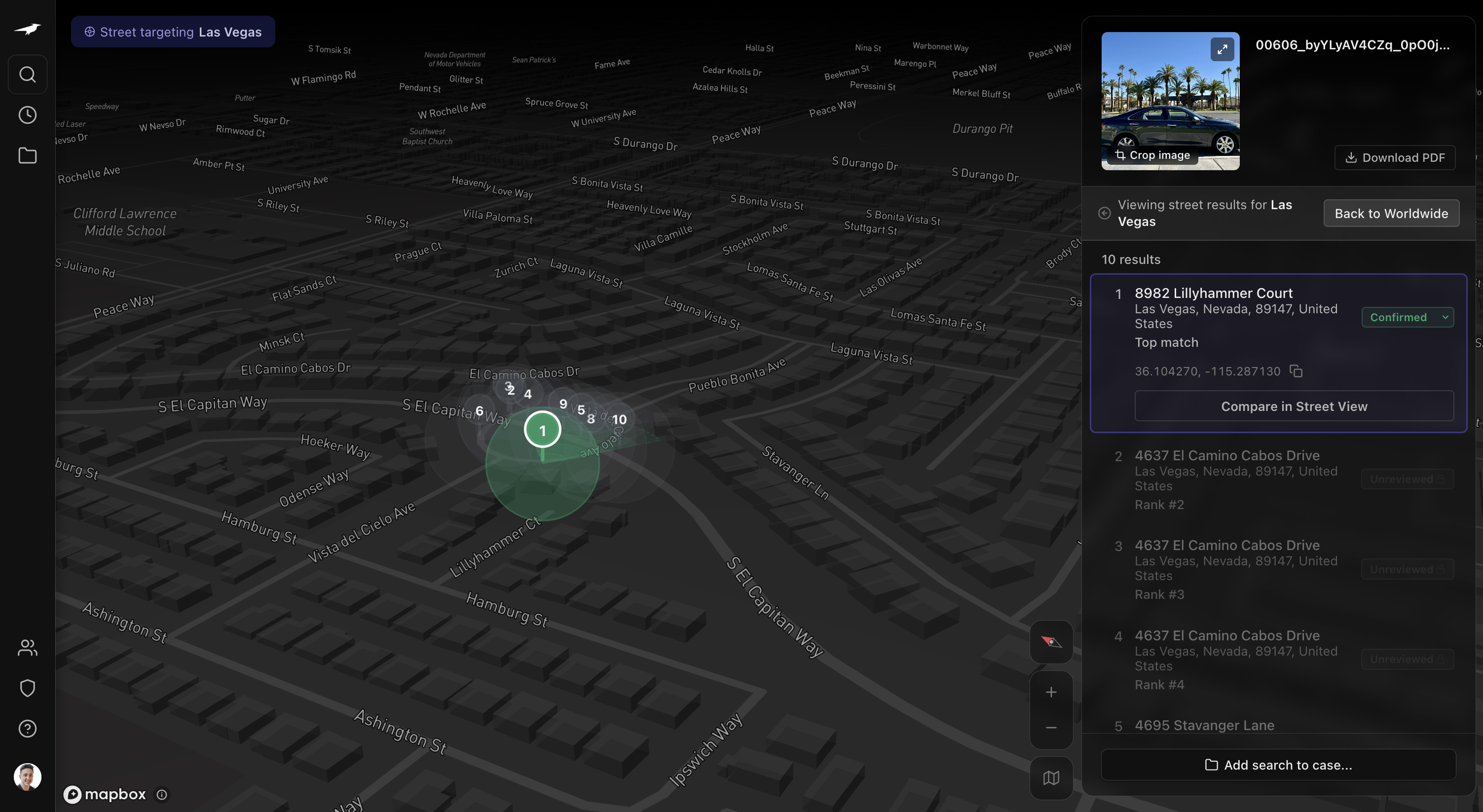
Street Targeting delivers meter-level precision even when clear landmarks are absent — narrowing broad regions to exact locations in seconds.

Input
Phone photo
Phone photograph of a dark Lexus ES parked on a palm-lined residential street
Parked vehicle · residential street · no address in frame
Raven · Street Targeting
Refines a low-context image into a precise, real-world location using visual signal alignment.
Model view
Direct Inference
$ downsampled · street features
Top prediction confirmed
Top prediction · confirmed
Street Targeting result — 10 candidates ranked, top match confirmed at 8982 Lillyhammer Court
Identified
8982 Lillyhammer Court
Coordinates
36.1043°N, −115.2871°W
Rank
1 of 10
Topmatch · confirmed
§04Identify Car·CarID v2.0 04

Make. Model. Year. From a single image.

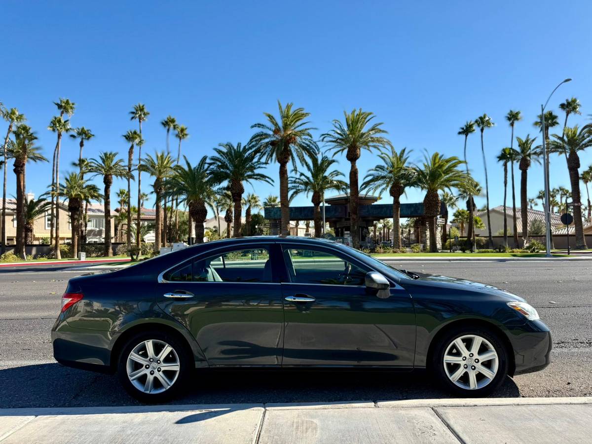
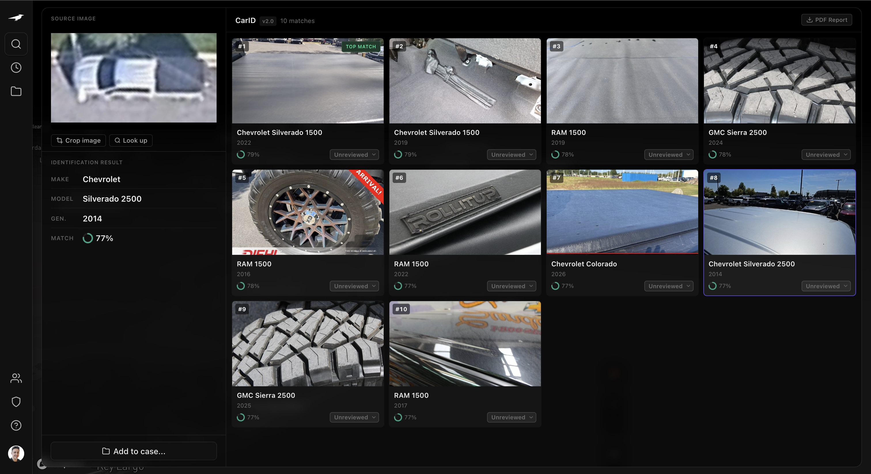
Analyzes partial visual signals across interior and exterior — body lines, materials, trim, controls, lighting — and compares them against a learned vehicle representation to identify make, model, and year with ranked candidates.

It returns ranked candidates scored by visual similarity, enabling fast and reliable identification.

Input
Partial · blurred
Low-resolution, blurred partial photograph of a pickup truck rear bumper corner
Rear bumper corner · blurred · no full-body view
Raven · CarID v2
Compares visual features to surface the closest vehicle matches — make, model, and year.
Model view
Vehicle ID Model
$ input → vehicle signature
Ranked by visual similarity
CarID workspace — source image with identification result (Chevrolet Silverado 2500, 2014, 77% match) beside 10 candidate matches ranked by visual similarity
Identified
2014 Chevrolet Silverado 2500
Candidates
10 ranked · make, model, year
Rank
Operator-selected · #8
77%match
§05Case management 05

Case management, built for visual investigations.

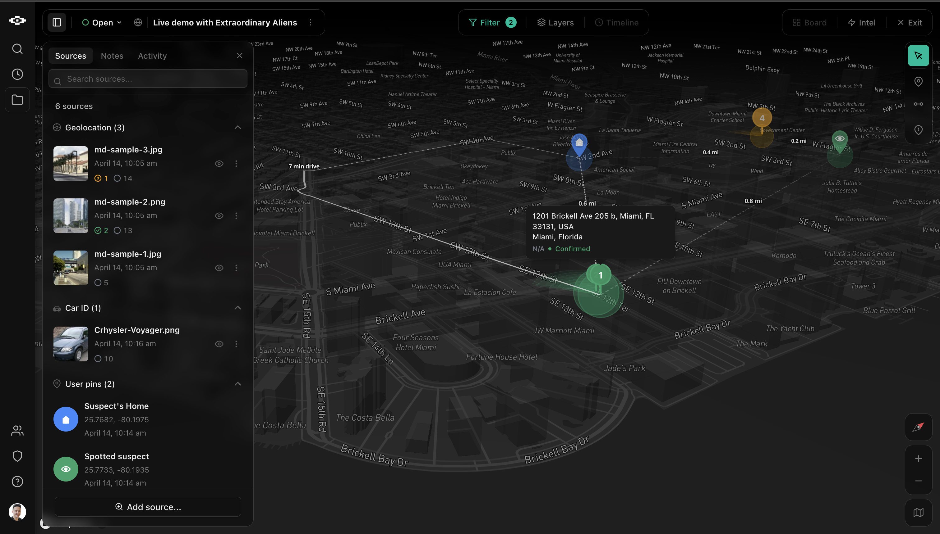
Every search, pin, and source lives inside a shared case. Geolocations, vehicle IDs, and operator annotations pile onto one map.

Raven measures the distance between them, clusters the confident ones, and surfaces the leads that matter — automatically.

Auto-clustered. No manual correlation.

Sources · 6 added
Live case
GEO
Miami, FL — Find Region
14:22 · IMG_8125.jpg
94%
CAR
2019 Honda Civic Si
14:24 · bumper_partial.png
87%
OP
Home — S. Biscayne Dr
14:25 · operator pin
fixed
GEO
Little Havana block
14:31 · IMG_8141.jpg
89%
OP
Target address
14:35 · operator pin
fixed
TIP
Anonymous · street observation
1h ago · ingest channel
med
$ fragmented · mixed sensors · ungrouped
Raven · Case Intelligence
Measures distance between sources, scores proximity and confidence, and surfaces the tightest clusters — as the case grows.
Leads · 3 surfaced
Auto-clustered
1
1423 SW 12th Ave · Little Havana
2 sources · 8 m apart · visual + vehicle
High
2
Biscayne corridor
3 sources · 142 m cluster · mixed
Medium
3
Target address · standalone
1 operator pin · unsupported
Low
$ ranked · distance × confidence × recency
One map. Every lead.
A burglary case — Sources panel with 4 geolocation results and 2 user pins, clustered numbered pins on a Miami-area map
IN PROGRESS · MIAMI
A burglary case
6sources
4geolocations
2user pins
2clusters surfaced

A safer world has no blind spots.

Raven is available to verified agencies and investigative teams. Book a demo to see it run on your own imagery.